Volume : 1 | Issue : 1
Review
Review of the geology of mamfe sedimentary basin sw, cameroon central Africa
Edwin Ayuk Ndip,1,2,3,4 Agyingyi CM,3,4 Nton ME,2 Oladunjoye MA2
1Institue for life and Earth Sciences, University of Pan African, Nigeria
2Department of Geology, University of Ibadan, Nigeria
3Petroleum Geosciences Research Group, University of Buea, Cameroon
4Department of Geology, University of Buea, Cameroon
Received: January 09, 2018 | Published:March 23, 2018
Abstract
This paper presents a review of the tectonic evolution, stratigraphy, paleontology, hydrogeological aspects and economic geology of the Mamfe basin. The main structures are basement –involved and detached fault and simple symmetrical fold with NE-SW trend. The basin measures 130 km in length and the widest part is about 60 km and a maximum area of 3200 km2. The maximum sediment thickness is estimated at 4–7 km and the sedimentary infill includes a lower alluvial fans to fluvial basal conglomerate and conglomeratic sandstone, a middle alternating (cyclic) aqueous to anoxic deep lake bottom black shale and limestone unit and an upper fluvial to transitional deltaic nearshore conglomeratic sandstone unit. The Ostracod fauna from the shale are very similar to the coeval fauna from adjacent Benue trough. The reported fauna have no biostratigraphic significance because of their uncertain age, low diversity, and cosmopolitan distribution during the early Cretaceous. Over 30 salt springs exist across the Mamfe basin with the most concentrated yielding 79 g/L of high quality halite. Several mineral indices (including diamond) have been identify and the geological condition favour the occurrences of hydrocarbon.
Keywords: Stratigraphy, Paleontology, Hydrogeological aspect, Economic geology, Mamfe basin
Introduction
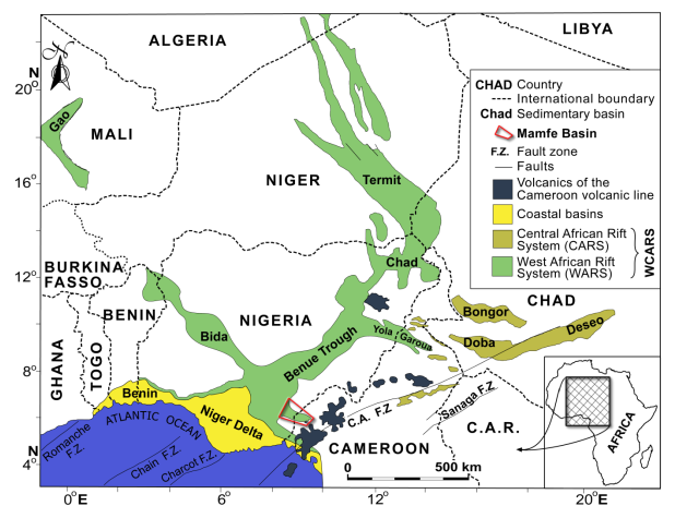
The Mamfe Sedimentary Basin in the SW region of Cameroon is also known Mamfe embayment, Ikom-Mamfe embayment, Mamfe Gulf, or Mamfe Rift.1-13 It is a small intra-continental basin that forms an arm of the Benue Trough of Nigeria (Figure 1) extending into Cameroon.14 The basin is part of the West and Central African Rift System (WCARS) that is intimately associated with the opening of the South Atlantic Ocean and the formation of the Gulf of Guinea.15-17 Several research projects have been on going in the Mamfe basin regarding geology and lithostratigraphy. With the current need of the government of Cameroon to avoid entering the state of an emergent nation in 2035, there is every need for the geology of this hinterland basins to be reviewed in order to highlight its economic potential. Therefore, the aim of this study is to present a review of the tectonic evolution, stratigraphy, hydrogeological aspects, paleontology and economic geology of the Mamfe basin. The data base for this contribution comes from previous research on the Mamfe basin. This is significant because it will awaken exploration and exploitation activities in the Mamfe sedimentary basin and further call for the government of Cameroon to fund research in the basin.
Geographical setting
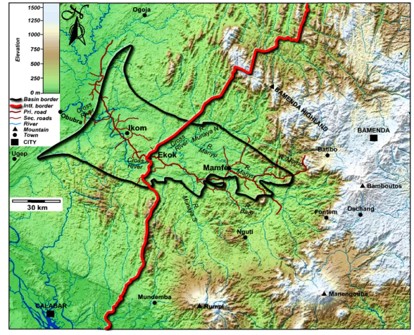
The Mamfe Sedimentary Basin located between 5°30’ to 6°00’N and 8°15’ to 9°45’ E underlies a coastal plain in Cameroon with low to slightly high relief whose heights range from 30 to 300m.4,18 It is locally bordered by high igneous terrains (Mount Nda Ali: 1200 m, Mount Mbinda: 1000 m, Nkogho hills: up to 600 m). The basin is regionally bordered by upland areas (Figure 2) (Mount Rumpi, Bambouto, Bamenda, Manengouba and Koupe), which are part of the Cameroon Volcanic Line.19,20 The Mamfe Basin is administratively situated in the Manyu Division made up of four sub-divisions (Mamfe Center, Eyumojock, Upper Bayang, and Akwaya) and occupied by three main ethnic groups: the Kenyangs, Akwayas, and Ejagham.18 It measures 130 km in length and the widest part is about 60 km and a maximum area of 3200 km2.21 The maximum sediment thickness is estimated at 4 –7 km.22,23 The climate in this division is hot and humid and consists of a rainy and a dry season modified by the deviation of the monsoon and the relief of Mount Cameroon.24 The vegetation is dominantly that of the equatorial rain forest,18 and the drainage system is principally that of the Cross River (Figure 3) whose main source is found in Mount Bambouto.25 The sources of its main tributaries the Munaya and Badi Rivers are at Mount Rumpi and Nda Ali respectively.18
Tectonic evolution
The Mamfe Basin is an appendix of the Benue Trough located at the South East border. The Benue Trough and associated basins (Figure 4) including the Gongola Trough (extending N-S mostly in Nigeria), Bornu (extending W-E and reaching Cameroon eastwards) and Yola basins are located in the convergence of the West African Rift System (WARS) and Central African Rift System (CARS) in the junction between the Northwest, Northeast and Southern African plates.9 The Benue Trough represents the abandoned arm of a ridge-ridge-fault triple junction at the origin of the opening of the South Atlantic Basin and extension in the WARS and CARS.9,26-30 The trough represents a major direction of NE-SW filled with continental and marine sediments. Subsidence in the Benue Trough begins during the Late Jurassic - Barremian interval;9,30,31 the oldest sediments, Barremian in age 30 are conglomerates, covered with lacustrine deposits. In north-eastern Nigeria, marine conditions partly occurred during the latest Cenomanian latest ‘‘Senonian’’ (Campanian Maastrichtian?) interval.

|
Figure 4 Map of the Benue trough, the West and Central African rift systems (WCARS) in western Central Africa (After Genik, 1993). |
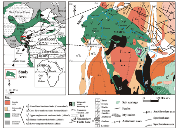
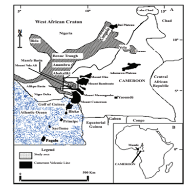
The Mamfe basin is laterally correlated to the Asu River Formation in Nigeria.9 It is an important tectono-sedimentary and intra-continental geological structure.14 The Mamfe sedimentary basin is a rift basin that was initiated by the response of the Precambrian basement of this region to the break-up of Gondwana and subsequent separation of South American from the African continental plate.2,5,9,11,12 Like other rift basins of this sub-region, the Mamfe Basin is part of the West Central African Rift System (WCARS) that is intimately associated with the opening of the South Atlantic Ocean and the formation of the Gulf of Guinea.17,32 During its formation, this basin appeared as a bifurcation or an eastern tectonic arm that extended eastward from the south-eastern portion of the Benue Trough into the south-western part of Cameroon (Figure 5). It should be noted that, like the Mamfe Basin in the south-east, a second arm also extended eastward into Cameroon, but from the north-western portion of the Benue Trough, known as the Garoua Basin.
Abolo33 outlined a five phased tectono-stratigraphic evolution of the Mamfe Basin slightly modified here as follows:
- Eo-rift phase that was characterized by the initial rifting and possible deposition of the first alluvial fan conglomerates during the Barriasian-Pre Barremian.
- Syn-rift and subsidence phase (Barremian-Early Albian and Late Albian-Cenomanian) during which rifting and alluvial fan conglomerates deposition continued together with fluvial sandstones and lacustrine shales.
- Post-rift phase-1 characterized by folding, faulting and erosion which occurred during the Santonian-Early Campanian in response to the Abakaliki tectonic event in Nigeria.
- Post-rift phase-2 which include all other events that occurred during the latest Cretaceous and beyond; continued erosion, magmatization and possibly uplift.
Stratigraphy of Mamfe Basin |
Le Fur |
Dumort, (1968) |
Eseme, (2006) |
Abolo, (2008) |
Bassey et al., (2013) |
Eyong et al., (2013) |
||
|---|---|---|---|---|---|---|---|---|
Age |
Formation |
|
Series |
Series |
Members |
|
Formation |
Members |
Tertiary |
|
|
Volcanics |
Igneous rocks |
|
|
|
volcanics |
Cenomanian |
Mamfe Formation |
Cg5 |
Cross River sandstone series |
Arkosic and conglomeratic sandstones |
Manyu |
Kesham |
Cross River |
Esagem |
Albian |
Cg4 |
Clayey sandstone series |
Shales (oolitic, bituminous) |
Nfaitok |
Manyu |
Nfaitok |
Bagba |
|
Cg3 |
Upper conglomeratic series |
Sandstones and conglomerates |
Okoyong |
|||||
Cg2 |
Manyu clayey sandstone series |
Shales intercalated with sandstones; evaporites? |
|
Mamfe |
||||
Cg1 |
Lower sandy conglomerate series |
Conglomeratic sandstones with basement fragments |
Etoko/ |
|
Manyu |
|||
|
|
|
|
|
|
Ngeme |
Basai/Inokun |
|
|
Basement |
Granito-gneissic |
Granito-gneissic |
Granito-gneissic |
Granito-gneissic |
Basement |
Granito-gneissic |
Granito-gneissic |
Table 2 Sample mesh report
Stratigraphy
The stratigraphic framework of the Mamfe Basin was initiated by the early authors; Wilson 1, Le Fur 34, Dumort 4. The sedimentary infill of the Mamfe Basin is collectively and formally referred to as the Mamfe Formation. The type locality of this formation is at the banks of River Manyu in Mamfe.1,3,35 Further and most recent publications are marked by gross inconsistencies in the manner in which each author sub-divides and present the framework of the sedimentary deposits of this basin. Le Fur 34 had earlier recognized and sub-divided these rocks into five units (Series) which were identified as C1 to C5 respectively from base to top. IRGM/DYU1 (2000) recognized only three units (unspecified) that were later on supported by Abolo 33 who packaged the entire 4000 m thick sedimentary infill of the Mamfe Basin into a single formation made up of three members. Eyong et al.17, on the other hand, sub-divided these same rocks into five formations some which were further sub-divided into several members. Bassey et al.36 further compounded the controversies by recognizing only two members from a lone Mamfe Formation. However, preliminary outcomes of current research aimed at appropriately correcting the stratigraphic framework of the Mamfe Basin are pointing to three fundamental stratigraphic units (Formations) for this basin.
Paleontology
Fossils that have thus far been identified in sediments of the Mamfe Basin include impressions of Lower Cretaceous ichthyodectiform fish Proportheus kameruni jaekel,1 Otracods ichnofossils, conchostracan of the genus Estheriina,17 and abundant microflora.37,38 The reported fauna have no biostratigraphic significance because of their uncertain age, low diversity, and cosmopolitan distribution during the early Cretaceous.39-41 Also, recent dinosaur trackways have been reported in the Cretaceous strata at Nfaitok Bridge by JE Martin.
Hydrogeology
The Mamfe Formation constitutes the main source of groundwater supply in the basin. In area of shallow depth the basement complex can supply groundwater. Since ground water is confined to the zones of weathered rock, joints and fractures in the basin. Mamfe basin is characterized by evaporate deposits that constitute the sediments of the basin high mineralized Soduim Chloride composition and Total dissolved solute higher than sea water range from 13000 to 36000 mg/L. Meanwhile, the large part of the water of the basin is in good quality and content (Ca, Na) - HCO3).42-44
Economic geology
Important mineral indices have so far been identified in the basin .Lead, Zinc, Rutile and Sapphire have been identified by Lapplaine and Soba, 45 Du Mort,4 Ndougsa-Mbarga et al.11 Kanouo,18 Kanouo et al. 46 Nguimbous-Kouoh, Takougam, Nouayou, Tabod and Manguelle-Dicoum.12 Carbonate, sulphide and evaporite minerals have widely been reported in Cretaceous sedimentary facies of the Mamfe Basin in Cameroon.1,4,34 In addition, over 30 salt springs exist across the Mamfe basin 47 with the most concentrated yielding 79 g/L of high quality halite (Eseme, 2001). Gem corundum and coarse zircon have been reported in detrital sediments (in Nsanaragati) at about 10 km east of the nearest basaltic flow in Ekok.18,46 Although not yet confirmed, the presence of diamond indices within sedimentary clasts in the western part of Mamfe Basin is mentioned in Laplaine and Soba.45 The aspect of the depositional environments and petroleum geology of the Mamfe Basin has been reported by Wright et al.48 Ajonina;14 Ajonina et al. 49-51 Bassey and Ajonina;52 Eyong,41 Eseme et al. 53 Abolo;33 Bassey et al.36 Eyong et al.41 Njoh and Njie.54 Geological condition that favour the discovery of hydrocarbon occurrence in the Mamfe basin. SNH 55 proposed the hydrocarbons generation and migration as followed:
- Occurred during Santonian and Early Tertiary.
- Source rocks are located at the center of the basin. Shallow reservoirs appear at the east due to uplifting and erosion, suggesting hydrocarbon migration to the surface and hydrocarbon destruction by meteoric waters. Deep reservoirs are elsewhere across the basin.
Geological models suggest that hydrocarbons can still be trapped within deep structures.
Discussions and Conclusion
The geology of the Mamfe sedimentary basin is characterized with four stage tectono-stratigraphic evolution that is the Eo-rift phase, Syn-rift and subsidence phase, Post-rift phase-1, and Post-rift phase-2 in which the following type of rock have being deposited: alluvial fan conglomerates, fluvial sandstones and lacustrine shales, fault-bounded granitogneissic rocks of the Pan-African Mobile Belt (550 ± 100 Ma) and Tertiary anorogenic and effusive basic intermediate rocks such as syenites, diorites, trachytes and basalts that belong to the CVL. The stratigraphy succession of the Mamfe basin is highly controversial as there is no accepted lithostratigraphy framework for the basin. However current research is pointing to three fundamental stratigraphic member for this basin. Until these findings are published, it is generally agreed by many that the rocks of this basin can best be sub-divided intso three members: a lower alluvial fan conglomerate to a fluvial channel cross bedded conglomeratic sandstone, a middle predominantly repeated sequences of alternating black shales, limestones, sandstone and evaporates (lacustrine), and another fluvial sandstone unit at the top of the basin. In term of its economics potential the basin is endowed with several mineral indices (including diamond) and the geological condition favour the occurrences of hydrocarbon.References
- Wilson RC. Notes on the Geology of the Mamfe Division, Cameroons Province. Geological Survey of Nigeria Occasional Paper # 6. 1928;23.
- Cratchley CR, Jones JP. An interpretation of geology and gravity anomalies of the Benue valley, Nigeria. Overseas Geological Paper. 1965; 9:1−28.
- Reyment RA. Aspects of the geology of Nigeria. Ibadan University press, Ibadan. 1965;145.
- Dumort JC. Carte Géologique de reconnaissance a 1/500000 avec notice explicative. Feuille Douala-Quest. Direction des Mines et de Géologie, Cameroun. 1968.
- Olade MA. Evolution of Nigeria's Benue Trough (Aulacogen): a tectonic model. Geological Magazine. 1975;112:575−583.
- Whiteman AJ. Nigeria: Its Petroleum Resources and Potentials. Graham and Trotman, 1982;1(2):394.
- Adediran SA, Adegoke OS. Evolution of sedimentary basins of the Gulf of Guinea. In: Matheis G, Schandlemeier H, eds, Current Research in African Earth Sciences, Balkema, Rotterdam. 1987;283−286.
- Petters SW, Okereke CS, Nwajide CS. Geology of Mamfe rift, SE Nigeria. In: Matheis G, Schandlemeier H, eds., Current Research in African Earth Sciences, Balkema, Rotterdam. 1987;299−300.
- Benkhelil J. The origin and evolution of the Cretaceous Benue Trough (Nigeria). Journal of African Earth Sciences. 1989;8(2-4):251−2824.
- Edet A, Okereke CS. Hydrogeologic framework of the shallow aquifers in the Ikom–Mamfe Embayment, Nigeria using an integrated approach. Journal of African Earth Sciences. 2014;92:25−44.
- Ndougsa-Mbarga T. Etude géophysique, par méthode gravimétrique des structures profondes et superficielles de la région de Mamfé, Thèse de Doctorat, Faculté des Sciences, Université de Yaoundé I, Yaoundé, Cameroun. 2004;62.
- Nguimbous-Kouoh JJ, Takougam EMT, Nouayou R, et al. Structural Interpretation of the Mamfe Sedimentary Basin of Southwestern Cameroon along the Manyu River Using Audiomagnetotellurics Survey. ISRN Geophysics. 2012;7.
- Oden MI, Egeh EU, Amah EA. The Ikom-Mamfe basin, Nigeria: A study of fracture and mineral vein lineament trends and Cretaceous deformations. Journal of African Earth Sciences. 2015;101:35−41.
- Ajonina HN, Bassey CE. Stratigraphy and depositional environments of the Mamfe Formation and its implication on the tectono-sedimentary evolution of the Ikom-Mamfe Embayment. Nigerian Association of Petroleum Explorationist (NAPE) 15th Annual international Conference and Exhibition, Lagos, Nigeria. (1997):39.
- Petters SW. Stratigraphic evolution of the Benue Trough and its implications for the Upper Cretaceous paleogeography of West Africa. Journal of Geology. 1978a;86:311−322.
- Fairhead JD, Okereke CS, Nnange JM. Crustal structure of the Mamfe basin, West Africa, based on gravity data. Tectonophysics. 1991;186:351−358.
- Eyong JT, Wignall P, Fantong WY, et al. Paragenetic sequences of carbonate and sulphide minerals of the Mamfe Basin (Cameroon) Indicators of palaeo-fluids, palaeo-oxygen levels and diagenetic zones. Journal of African Earth Sciences. 2013;86:25−44.
- Kanouo SN. Etude géologique des indices de minéralisation de saphir dans la partie Sud du bassin sédimentaire de Mamfe. Mémoire de D.E.A, Université de Yaoundé I. 2008;91.
- Fitton JG. The Benue Trough and the Cameroon volcanic line — a migrating rift system in West Africa. Earth Planetary Science Letters. 1980;51(1):132–138.
- Kamgang P, Chazot G, Njonfang E, et al. Mantle sources and magma evolution beneath the Cameroon volcanic line .Geochemistry of Mafic rocks from the Bamenda mountains (NW, Cameroon). Gondwana Res. 2013;24:727−741.
- Regnoult JM. Synthese Geologique du Cameroun, Ministere des mines, Sodexic Yaounde, eophysics. 1986;7.
- Okereke CS, Fairhead JD. A catalogue of gravity measurements from Nigeria and Cameroon. Report, Department of Earth Sciences, Leeds University. 1984.
- Fitches B, Abolo M, Barnard P, et al. Cretaceous subsidence, Tertiary uplift and petroleum system of the Mamfe Basin in SW Cameroon, Central Africa. Africa: New Plays–New Perspectives. Houston Geological Society and Petroleum Exploration Society of Great Britain Second International Symposium, Abstracts, Houston. 2003;43.
- Suchel JB. The distribution of rainfalls and rainfall pattern in Cameroon Talence. 1972.
- Olivry JC. Rivers and Rivers of Cameroon, Paris. Hydrographic Monograph, Orstom. 1986:734.
- Popoff M. Du Gondwana a l’Atlantique sud les connexions du fosse de la Benoue avecles bassins du Nord- Est bresilien jusque a l’overture du golf de guinee au cretace inferieur. J Afr Earth sci. 1988;7:409−431.
- Fairhead JD, Okereke CS. Crustal thinning and extension beneath the Benue trough based on gravity studies. Journal of African Earth Sciences. (1990);11(3-4):329−335.
- Genik GJ. Petroleum geology of Cretaceous-Tertiary Rift Basins in Niger, Chad and Central African Republic. AAPG Bulletin. 1993;77(8):1405−1434.
- Genik GJ. Regional framework, structural and petroleum aspects of rift basins in Niger, Chad and the Central African Republic (CAR). Tectonophysics. 1992;213(1-2):169−185.
- Brunet M, Dejax J, Brillanceau A, et al. Mise en evidence d’une sedimentation precoce d’age Barremien dans le fosse de la Benoue en Afrique occidentale (Bassin du mayo Oulo lere Cameroun) en relation avec l’ouverture de l’atlantique sud .CR. Acad.sci. Paris ser II. 1998;306:1125−1130.
- Guiraud R, Bosworth W, Thierry J, et al. Phanerozoic geological evolution of Northern and Central Africa: An overview. Journal of African Earth Sciences. 2005;43(1-3):83−143.
- Petters SW. Mid-Cretaceous paleoenvironments and biostratigraphy of the Benue Trough, Nigeria. Geological Society of America Bulletin. 1978b;89:151−154.
- Abolo MG. Geology and petroleum potential of the Mamfe Basin, Cameroon, Central Africa, Africa Geoscience Review. Special Publication. 2008;1(2):65−77.
- Le Fur Y. Mission Socle-Crétacé. Rapport 1964–1965 sur les indices de Plomb et Zinc du Golfe de Mamfé. Rapport, B. R. G. M., Cameroun. 1965.
- Reyment RA. The stratigraphy of the Southern Cameroons. Geologiska Föreningens I Stockholm Förhandlingar. 1954;76:661−683.
- Bassey CE, Eminue OO, Ajonina HN. Stratigraphy and depositional environments of the Mamfe Formation and its implication on the tectonosedimentary evolution of the Ikom-Mamfe Embayment, West Africa. Central European Journal of Geosciences. 2013;5(3):394−406.
- Ajonina HN, Betzler C, Volkheimer W, et al. Palynology and depositional environments of Early Cretaceous sediments in the Mamfe Basin, west Africa and their relationship to other Gondwanic regions in South America. 12th International Palynological Congress (IPC-XII) 8th International Organisation of Paleobotany Conference (IOPC), Bonn, Germany. 2008;8.
- Ajonina HN, Betzler C, Jaramillo C. Paleoclimatic significance of an Early Cretaceous fan-delta sedimentary succession in the eastern Mamfe Basin, SW Cameroon. 2010 Afrika gruppe deutscher Geowissenschaftler (AdG), Frankfurt, Germany. 2010;30.
- Maisey JG. Continental break up and the distribution of fishes of Western Gondwana during the Early Cretaceous. Cretaceous Research. 2000;21(2-3):281−314.
- Lana CC, Carvalho IS. Cretaceous conchostracans from Potiguar Basin (northeast Brazil): relationships with West African conchostracan faunas and palaeoecological inferences. Cretaceous Research. 2002;23(3):351−362.
- Eyong JT. Litho-Biostratigraphy of the Mamfe Cretaceous Basin, SW. Province of Cameroon–West Africa. Ph.D thesis, University of Leeds. 2003;265.
- Mafany GT, Fantong WY, Nkeng GE. Groundwater quality in Cameroon and its vulnerability to pollution. In Ground water pollution in Africa. Yong Xin Xu Publisher. Brent Usher. 2006;47−54.
- Kebede S, Travi Y, Alemayehu T, et al. Groundwater recharge, circulation and geochemical evolution in the source region of the Blue Nile River, Ethiopia. Applied Geochemistry. 2005;20(9):1658–1676.
- Kebede S, Travi Y. Origin of the δ18O and δ2H composition of meteoric waters in Ethiopia. Quaternary International. 2012;257:4–12.
- Laplaine L, Soba D. Rapport du service géologique pour les années 1965-1966–1967, prospection de saphirs dans le bassin crétacé de Mamfé. Archives BRGM /DMG/ MINMEE. 1967.
- Kanouo NS, Yongue RF, Chen S, et al. Greyish-Black Rutile Megaclasts from the Nsanaragati Gem Placer, SW Cameroon: Geochemical Features and Genesis. Journal of Geography and Geology. 2012;4(2):134−146.
- MINMEE (Ministere des Mines, Eau et Energie). Re-awakening of artisanal kitchen salt mining activities in the sedimentary gulf of Mamfe. Report, Ministry of Mines, Water and Energy, Cameroon. 1988.
- Wright JB, Hasting DA, Jones WB, et al. Geology and Mineral Resources of West Africa. George Allen and Union. 1985;188.
- Ajonina HN, Ajibola OA, Bassey CE. The Mamfe Basin, SE Nigeria and SW Cameroon: A review of basin filling model and tectonic evolution. Journal of the Geosciences Society of Cameroon. 2001;1:24−25.
- Ajonina HN, Njilah IK, Ndjeng E, et al. Sedimentology and reservoir potential of sandstones of the Mamfe Formation, Mamfe Basin, southeast Nigeria and southwest Cameroon. 2006;36:117−132.
- Ajonina HN, Betzle C, Eyong JT, et al. Stratigraphy and sedimentary evolution of the Mamfe Basin, southwest Cameroon, West Africa. 2007;57.
- Bassey CE, Ajonina HN. Petrology of the Cenomanian Upper Member of the Mamfe Formation, Mamfe Embayment, southwestern Cameroon. Journal of Mining and Geology. 2002;38:27−34.
- Eseme E, Littke R, Agyingi CM. Geochemical characterization of a Cretaceous black shale from the Mamfe Basin, Cameroon. Petroleum Geoscience. 2006a;12(1): 69−74.
- Njoh OA, Njie SM. Hydrocarbon Source Rock Potential of the Lacustrine Black Shale Unit, Mamfe Basin, Cameroon, West Africa. Earth Science Research. 2016;5(2):217−230.
- SNH/Serge E. Mamfe basin: element of the petroleum system. Report No 9673/IIc. 2015;201.


